HA GIANG
HA GIANG IN BRIEF
Location: Located at the highest latitude in Vietnam, Ha Giang is surrounded by Cao Bang on the east, Tuyen Quang on the south, Lao Cai, and Yen Bai on the west. It shares a border […]
Location: Located at the highest latitude in Vietnam, Ha Giang is surrounded by Cao Bang on the east, Tuyen Quang on the south, Lao Cai, and Yen Bai on the west. It shares a border […]
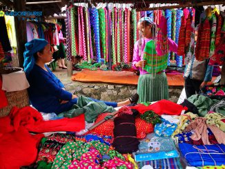
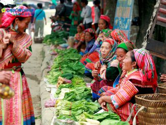
Dong Van market beckons ethnic groups living roughly within a 25km radius of the town. This primarily consists of White Hmong, Black Dao and Tay people living high and secluded up in the mountains. The colors of […]
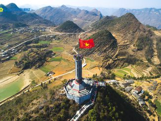
Vietnam, an S-shaped country has 4 points including easternmost, northernmost, westernmost, southernmost point while northernmost point in Lung Cu Commune, about 24km from the centre of Dong Van district, Ha Giang Province. Lung Cu Flagpole was […]
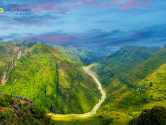
Nho Que River courses through the 1,500m high Mount Nghiem Son. The river is approximately 46km long, 5km of which is at the border of two countries, China and Vietnam. The rest of the river […]
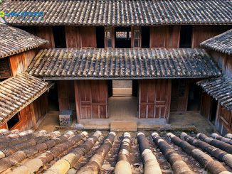
The Vuong Palace located in Dong Van Plateau, province of Ha Giang has been a well-known tourist destination for several years now. A century-old mansion and once home to an influential family headed by a powerful […]
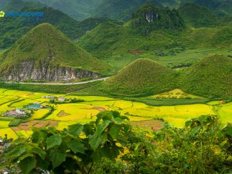
Nui Doi Quan Ba called Co Tien Moutain is regarded as an important destination in the tours to Dong Van rocky highland, an attractive place for professional photographers to come. As told by the legend, […]
MY CAD Trading & Services all rights reserved. Designed by Pixel Technology JSC